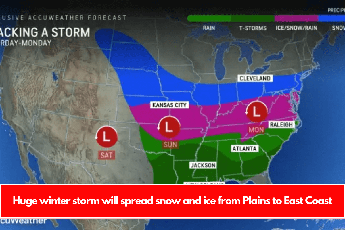
A large cross-country winter storm will spread snow and ice across nearly 1,500 miles, beginning this weekend in the Plains and ending next week along the Atlantic coast. Major travel disruptions are expected.
From this weekend to early next week, a massive storm will spread snow and ice across a 1,500-mile stretch of the Plains and Mississippi Valley, as well as many areas of the Appalachians and the Atlantic coast, according to AccuWeather meteorologists. Widespread travel issues will arise, and many areas will experience bitterly cold weather.
The storm is expected to be the first widespread cross-country winter storm of the season in the central and eastern United States, causing travel disruptions during the final days of the holiday break.
Much of South Dakota and Nebraska, as well as the Interstate 70 and 80 corridors from Iowa, Kansas, and Missouri to Ohio in the Central States, currently have enough snow to shovel and plow.
Just south of the snow zone, an area of ice with sleet and freezing rain will stretch from the Plains to the Ohio and Tennessee Valleys, roughly I-40 to I-70. Kansas City, Missouri; Tulsa, Oklahoma; and Springfield, Missouri, may experience significant ice accumulation, resulting in hazardous travel conditions.
As the storm approaches the Appalachians and the Atlantic coast, the area that may receive accumulating snow will extend from I-68 to I-80. This zone includes major Northeast hubs such as New York City, Philadelphia, Pittsburgh, and Baltimore.
The icy zone could extend across North Carolina, eastern Tennessee, and southern Virginia, including Richmond, Virginia, Chatanooga, Tennessee, and Raleigh, North Carolina.
As the storm moves east, the area of snow and ice will become more reliant on a separate storm in southeastern Canada. That storm in eastern Canada could push the US storm and its snow and ice zones further south, rather than allowing the US storm and its freezing and frozen precipitation to climb north along the Atlantic coast.
A more southern track may result in dry conditions in New York City and Philadelphia, snow in Raleigh, Richmond, and Washington, D.C., and ice or a wintry mix in Atlanta, Charlotte, and Greenville, South Carolina.
The storm is expected to be strong enough to cause thunderstorms south of the track, with some storms in the I-10 and I-20 corridors potentially severe.
As the cross-country storm moves through an expanding zone of Arctic air, frigid conditions will sweep into the Southern states, bringing some of the lowest temperatures in years before the middle of January.
More widespread winter storms may follow in the pattern, with one or more bringing snow and ice to the Gulf Coast states.
One such storm is being watched for that later next week. That same storm could start near the Gulf and move north, bringing snow and ice to the Atlantic coast.


Leave a Reply